
【作業用】伊丹・関空 リアルタイム3D航空機マップ 24時間ライブ / Lo-Fi Flight Radar – Osaka Itami & Kansai Airport (ITM/KIX) Live
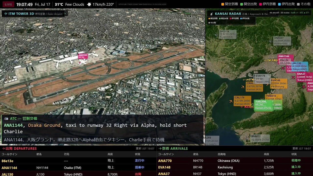
✈ 関西・伊丹空港 リアルタイム3Dフライトマップ 24時間ライブ
Live 3D Flight Map — Kansai (KIX) & Osaka Itami (ITM) Airport, Real-Time ATC & Weather
実際のADS-B航空機データと気象データをもとに、関西国際空港(KIX)と大阪伊丹空港(ITM)の
離着陸をリアルタイム3Dで24時間お届けするライブ配信です。
━━━━━━━━━━━━━━━━━━━━
🛫 見どころ
━━━━━━━━━━━━━━━━━━━━
・左:3Dタワービュー(離着陸をアップで/実際のGPS航跡どおりに機体が滑走路をトレース)
・右:広域レーダー(関西エリア全体の航空機を発着空港別に色分け表示)
・上部:現地の気象(気温・風・METAR)をリアルタイム表示
・下部:発着案内(FIDS)— 出発/到着便を日本語表示
・TTSによるATC(管制交信)&ATIS(空港情報)の再現放送
━━━━━━━━━━━━━━━━━━━━
🕐 タワー表示は時間帯で自動切替
━━━━━━━━━━━━━━━━━━━━
・7:00〜21:00 … 大阪伊丹空港(ITM)
・21:00〜翌7:00 … 関西国際空港(KIX)
※伊丹の運用時間に合わせて自動で切り替わります。
━━━━━━━━━━━━━━━━━━━━
🎨 広域レーダーの色分け
━━━━━━━━━━━━━━━━━━━━
🟠 関空到着 / 🟢 関空出発 / 🩷 伊丹到着 / 🔵 伊丹出発 / ⚪ その他
━━━━━━━━━━━━━━━━━━
📊 表示される情報
━━━━━━━━━━━━━━━━━━
・上部バー … 現在時刻/気温/天候/METAR(実況気象)
・下部パネル … 発着便(DEPARTURES/ARRIVALS)の便名・行先・高度・ステータス
・機体ラベル … コールサイン・高度・速度
━━━━━━━━━━━━━━━━━━
📻 ATC無線・ATIS放送について(大切なお知らせ)
━━━━━━━━━━━━━━━━━━
当配信で流れている管制交信(ATC)とATIS(飛行場情報放送)は、コンピュータで再現したシミュレーション音声です。
日本では電波法第59条により、傍受した無線通信の内容を第三者に伝えたり利用したりすることが禁止されています。そのため、海外の配信で聞けるような「本物の航空無線」を日本の空港ライブでお流しすることは、法律上できません。
その代わり当チャンネルでは——
🎙️ ATC … 実際のフライトデータ(便名・高度・位置)をもとに、その瞬間の空の状況に合った管制交信を自動生成
🎙️ ATIS … 実際の航空気象データ(METAR)から、本物と同じ形式の飛行場情報を約8分ごとに放送
という方法で、「音声は合成・中身のデータは本物」のリアルな無線の雰囲気を再現しています。
━━━━━━━━━━━━━━━━━━
ℹ️ データについて
━━━━━━━━━━━━━━━━━━
機体位置はADS-Bデータ、気象は航空気象電文(METAR)、空港3DモデルはOpenStreetMapをもとに描画しています。
※データの遅延・欠損・通信状況により、実際の運航と異なる場合があります。本配信は娯楽・情報提供を目的としたもので、運航・航法には使用できません。
━━━━━━━━━━━━━━━━━━✈ Kansai & Itami Airport Real-Time 3D Flight Map – 24-Hour Live
Live 3D Flight Map — Kansai (KIX) & Osaka Itami (ITM) Airport, Real-Time ATC & Weather
Based on actual ADS-B aircraft data and weather data, this live stream provides 24-hour real-time 3D footage of takeoffs and landings at Kansai International Airport (KIX) and Osaka Itami Airport (ITM).
━━━━━━━━━━━━━━━━━━━━
🛫 Highlights
━━━━━━━━━━━━━━━━━━━━
• Left: 3D Tower View (Close-up of takeoffs and landings / Aircraft trace the runway according to actual GPS flight paths)
• Right: Wide-Area Radar (Aircraft in the entire Kansai area are displayed in different colors by departure and arrival airports)
• Top: Real-time display of local weather (temperature, wind, METAR)
• Bottom: Departure and Arrival Information (FIDS) — Departures/arrivals displayed in Japanese
• Reconstruction broadcast of ATC (Air Traffic Control) & ATIS (Airport Information) by TTS
━━━━━━━━━━━━━━━━━━━━
🕐 Tower display automatically switches depending on the time of day
━━━━━━━━━━━━━━━━━━━━
• 6:45〜21:15 … Osaka Itami Airport (ITM)
• 21:15 – 6:45 the following day … Kansai International Airport (KIX)
*The system automatically switches to match Itami’s operating hours.
━━━━━━━━━━━━━━━━━━━━
🎨 Wide-area radar color coding
━━━━━━━━━━━━━━━━━━━━
🟠 Kansai Airport arrival / 🟢 Kansai Airport departure / 🩷 Itami Airport arrival / 🔵 Itami Airport departure / ⚪ Other
━━━━━━━━━━━━━━━━━━
📊 Information displayed
━━━━━━━━━━━━━━━━━━
• Top bar… Current time / Temperature / Weather / METAR (Current weather conditions)
• Bottom panel… Flight number, destination, altitude, and status of arriving and departing flights (DEPARTURES/ARRIVALS)
• Aircraft label… Call sign, altitude, and speed
━━━━━━━━━━━━━━━━━━
📻 Regarding ATC Radio and ATIS Broadcasts (Important Notice)
━━━━━━━━━━━━━━━━━━
The air traffic control (ATC) and ATIS (airport information broadcasts) played in this stream are computer-generated simulations.
In Japan, Article 59 of the Radio Law prohibits the transmission or use of intercepted radio communications to third parties. Therefore, it is legally impossible to broadcast “real aviation radio” like that heard in overseas streams during live broadcasts from Japanese airports.
Instead, this channel uses the following methods to recreate the realistic atmosphere of radio communication:
🎙️ ATC… Automatically generates air traffic control communications based on actual flight data (flight number, altitude, position) to match the current sky conditions.
🎙️ ATIS… Broadcasts airport information in the same format as real air traffic control approximately every 8 minutes, using actual aviation weather data (METAR).
This method recreates the atmosphere of realistic radio communication, where “the voice is synthesized, but the data is real.”
━━━━━━━━━━━━━━━━━━
ℹ️ About the Data
━━━━━━━━━━━━━━━━━━
Aircraft positions are based on ADS-B data, weather information is based on aviation weather telegrams (METAR), and airport 3D models are drawn based on OpenStreetMap.
*Due to data delays, data loss, and communication conditions, the actual flight may differ. This distribution is for entertainment and informational purposes only and cannot be used for flight operations or navigation.
━━━━━━━━━━━━━━━━━━
AloJapan.com