


Oleh_slobodeniuk/Getty Images
Alongside images of cherry blossoms, geishas, sumo wrestlers, and temples, Mount Fuji is one of the most recognizable symbols of Japan. But while tourists battle it out to climb the mountain — or, for the less committed, snap a quick selfie — most seem to forget that Mount Fuji is just one piece of the sprawling, 121,755-hectare Fuji-Hakone-Izu National Park. Unlike most national parks that unfold as a single continuous landmass, Fuji-Hakone-Izu National Park’s four areas spread across the prefectures of Tokyo, Kanagawa, Yamanashi, and Shizuoka. Mount Fuji and its surrounding lakes anchor the north, with Hakone to its east, the Izu Peninsula to the south, and the Izu Islands along the Pacific.
The common thread running through Fuji-Hakone-Izu National Park is geology, as its position along the Fuji Volcanic Zone has produced volcanic landforms that support its plants, forests, and species. That geological variety is popular with international tourists: Japan’s Ministry of the Environment recorded 3.9 million international visits to the park in 2024, more than three times the visitor count of the second-most-visited Aso-Kujū National Park, per Nippon.com.
Accessibility plays a big part in this. With most tourists landing at Tokyo’s Narita or Haneda airports, bullet trains connect the capital to the Fuji area, Hakone, and the Izu Peninsula. The Izu Islands — considered part of Tokyo Metropolis — require a ferry or a plane. However you get there, expect hikes through plunging cliffsides and dense forests, treks to the mouths of active volcanoes, and time spent soaking in hot springs.
Hiking trails and mountain views in Fuji-Hakone-Izu National Park
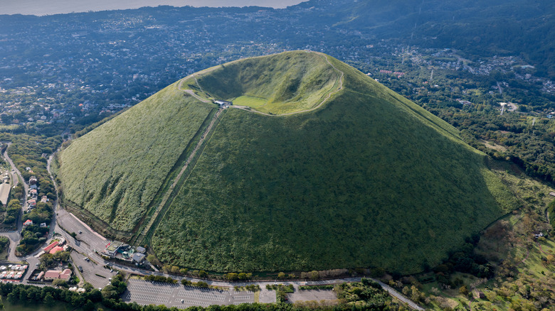
Maviy/Shutterstock
Fuji-Hakone-Izu National Park is packed with hiking trails — not least the four leading to Mount Fuji. But should you miss the July to September opening window — yes, it’s prohibited to climb Mount Fuji for most of the year — there are plenty of alternatives. In the Mount Fuji area, a five-hour trail loops around Lake Kawaguchi with scenic views of Mount Fuji and the mirror-like lake. On the Izu Peninsula, seven waterfalls await Kawazu Seven Falls hikers. Allow one to two hours to complete the trail, which comes with well-maintained, albeit wet and slippery paths and boardwalks.
For many Jogasaki Coast Walk hikers, the lighthouse is the spot for panoramic views of the Pacific Ocean breaking against lava-formed cliffs; the trail is best tackled without a fear of heights as it involves crossing a bridge suspended 74 feet over water. Meanwhile, Hakone’s four-hour Old Tokaido Road trail is as much a cultural experience as a natural one, with cedar trees and rocky paths punctuated by a village known for its woodcrafts, a rice beverage and mochi pit stop, and a Shinto shrine.
If it’s elevation you’re after, the national park rewards tough climbs with scenic views from its mountains. In the Fuji area, Mount Tenjo is accessible year-round. The easy 45-minute hike or a ride up via the Panoramic Ropeway makes it one of the more accessible ascents for mountain and lake views. Though Hakone’s Mount Myōjōgatake gets those Mount Fuji views, it’s also peppered with challenging elevations, something an AllTrails hiker wouldn’t recommend undertaking “unless you really want some endurance training.” The summit of Izu Peninsula’s verdant Mount Ōmuro is accessed by a chair lift, where you can complete a half-hour walking tour of its crater.
Volcanic beauty in the Izu Islands

Pruchawal Aiumporn/Getty Images
Volcanic geology is visible in more ways than one in the Izu Islands. A result of underwater volcanoes breaking through the ocean’s surface, the nine inhabited islands have their own volcanic trademarks. There is sand from broken-down lava and volcanic rock that line the shores, ranging from the white rhyolite sands at Niijima, Shikine, and Kōzu to black basalt sands at Ōshima Island, the largest isle in the archipelago.
Ōshima is home to the active volcano Mount Mihara. It’s a two-hour climb to the crater’s rim, which looks out over the surrounding Ura Sabaku, Japan’s only “desert.” Though you can’t climb Miyakejima Island’s Mount Ōyama, there are plenty of lava trails, hot springs, and bird-watching opportunities to keep you occupied. The lava-sculpted landscape also shapes Aogashima Island, whose topography is best described as a volcano sitting within a large one. Getting here requires dedication: As the archipelago’s most remote island, it takes a helicopter or ocean liner by way of neighboring island Hachijōjima to reach, and even then, you’re at the mercy of the weather. Once there, you’ll find that stargazing is one of the island’s main draws.
Kōzushima Island is much easier to access and has no shortage of hiking trails across its mountains, bays, lighthouses, shrines, and hot springs. Another bonus: It’s been designated a Dark Sky Island by DarkSky International, which explains its “Tokyo’s Planetarium” nickname. Looking for another National Park in Japan? You may want to check out Daisetsuzan, known as Japan’s Playground of the Gods for its dramatically rugged, wildflower-filled mountain range.
AloJapan.com