

 Credit: WeatherBell
Confidence is strongest from Sunday night through Wednesday night, when Japan should see a useful refresh with the deepest totals in west Hokkaido. Most Honshu resorts should come away with a widespread 10 cm-20 cm by then, while Kiroro has the clearest path to the biggest early total. A second Thursday-Saturday system still looks likely, but the guidance spreads out considerably on placement, intensity, snow levels, and wind, so the later period is better treated as a less certain follow-up round than a locked-in storm cycle.
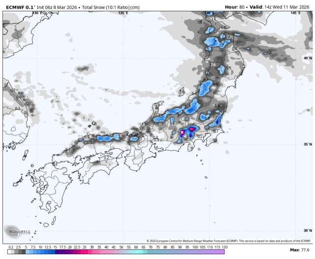
From Sunday night through Wednesday night, the individual models are reasonably well converged on a cold refresh across most of Japan, even though they still vary on which Hokkaido bands overperform. West Hokkaido has the best setup, with Kiroro favored for 29 cm-42 cm in the most dependable period and Niseko, Furano, and Sapporo Teine lined up for smaller but still worthwhile additions. Snow levels stay near sea level in Hokkaido and mostly below about 300 meters across central Honshu during the steadiest snow, so this first wave looks like a clean all-snow event for the major ski terrain. Snow quality also trends better in the north, where SLRs mostly sit in the 14-16 range for fairly light snow, while most Honshu resorts land closer to 10-14 for moderate to fair quality, with Shiga often lighter and Yuzawa occasionally denser. The main Honshu burst lines up late Monday through Tuesday, when Gala Yuzawa, Shiga Kogen, Nozawa, Akakura, and Naeba are favored for roughly 10 cm-20 cm and only moderate ridge-top wind issues.
From Thursday through Saturday, the individual models still agree that another wave reaches Japan, but they diverge much more on timing, intensity, snow levels, and wind. Central Honshu has a real chance at another 10 cm-30 cm, especially from Yuzawa through Myoko and Shiga, but the spread is large enough that some resorts could end up well below that if the drier solutions win out. West Hokkaido also has upside in that period, especially around Kiroro, although this part of the forecast looks increasingly wind-affected with exposed gusts pushing 60 km/h to 70 km/h in the snowier guidance. Snow levels still generally look manageable, but lower mountain conditions in the Yuzawa zone and at the lowest Hokkaido bases may start denser for a time as snow levels wobble into the 300 meters to 600 meters range before cooling again. During this second wave, SLRs look more mixed, mostly 11-14 at the colder resorts and closer to 7-10 in the wetter Yuzawa hours, so quality may improve as the storm matures rather than starting at its best.
Beyond Saturday, the forecast becomes much more speculative, with the individual models diverging sharply on whether Hokkaido sees another organized storm or simply stays showery. The best later signal is in Hokkaido, where a conservative read is for another 10 cm-30 cm from Sunday through Tuesday if the northern storm track hangs on, but several solutions keep totals lower than that and make it a nuisance refresh instead of a more meaningful storm. Central Honshu looks less convincing in that same stretch, with only spotty light snow favored right now and snow levels generally higher, often around 500 meters to 900 meters when precipitation shows up. That should translate to denser snow where it does fall, with SLRs more often in the 8-11 range, so the cleaner powder window still looks like the first half of the forecast rather than the back end.
Resort Forecast Totals (Sun Mar 08 – Wed Mar 11)
Kiroro – 29 cm-42 cm
Sapporo Teine – 15 cm-22 cm
Gala Yuzawa – 14 cm-20 cm
Shiga Kogen Okushiga Kogen – 13 cm-18 cm
Niseko Grand Hirafu – 12 cm-16 cm
Furano – 12 cm-16 cm
Naeba – 11 cm-15 cm
Akakura Onsen – 10 cm-14 cm
Nozawa Onsen – 10 cm-13 cm
Zao Onsen – 9 cm-12 cm
Madarao Kogen – 7 cm-10 cm
Hoshino Resort Tomamu – 7 cm-9 cm
Hakuba Happo-one – 7 cm-9 cm
Rusutsu – 3 cm-4 cm
Appi Kogen – 3 cm
AloJapan.com