

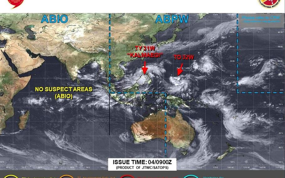
Tropical Depression 32W forms southwest of Guam on Tuesday; initial projections take it close to Philippines, Taiwan and possibly toward Okinawa in the long-term. (Joint Typhoon Warning Center)
7:10 p.m. Tuesday, Nov. 4, Guam time: Say hello to the 32nd numbered system of the northwest Pacific’s tropical cyclone season.
Tropical Depression 32W formed south-southwest of Guam on Tuesday. Its initial Joint Typhoon Warning Center forecast track takes it toward Luzon in the northern Philippines.
But long-range forecast ensembles do indicate a curve northeast toward Japan’s Yaeyama Islands and possibly Okinawa, so eyes are being cast in that direction as well.
At 4 p.m. Guam time, 32W was about 285 miles south-southwest of Naval Base Guam and about 1,520 miles southeast of Kadena Air Base, Okinawa, moving west at 10 mph with 30-mph sustained winds and 40-mph gusts at center.
If 32W continues moving as projected, JTWC forecasts it to make a beeline northwest in the coming days, peaking as a Category 4-equivalent typhoon at mid-afternoon Sunday when it’s still nearly 430 miles east of Metro Manila.
From there, 32W’s picture gets a tad fuzzy. Model-track guidance and the GFS and Euro forecast ensembles show a mix of straight run northwest toward Luzon and Taiwan, or a curve northeast toward Ishigaki and Miyako in southwestern Japan.
A couple of solutions go as far as Okinawa and off the coast of Japan’s main islands.
It’s way too early to draw definitive conclusions. Stay tuned.
AloJapan.com