

 Credit: WeatherBell
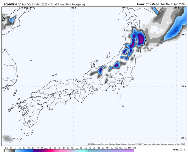
The clearest ski weather in Japan is a Thursday hit for north-central Honshu, followed by a long quieter stretch for the south and smaller, windier refreshers in Hokkaido next week. Confidence is highest from Thursday morning, April 2, through Thursday night, April 2, when guidance is most tightly grouped on timing and coverage. Expect dense snow and mixed snow levels in the Thursday storm, then mostly dry conditions Friday through Sunday before Hokkaido picks up a modest return of snow and stronger wind around Tuesday and Wednesday.
Thursday is the one period with tight timing confidence, and it is focused on north-central Honshu rather than Hokkaido. Guidance is well clustered on the storm arriving before dawn and peaking through Thursday, and it is also reasonably aligned on snow levels and on Zao being the windiest part of the event, even though snowfall intensity still varies. A reasonable expectation is 15 cm-30 cm in the favored terrain, with more common amounts closer to 4 cm-8 cm at Nozawa, Naeba, and Madarao, while Hakuba stays lighter. Snow levels generally sit between 900 meters and 1,400 meters, briefly nearing 1,600 meters around Zao, so lower elevations stay wetter while the upper mountain does better. SLRs mostly run 5-9, which points to very dense to dense snow, with Shiga closer to 8-12 for somewhat better quality. Zao can also see gusts around 80-90 km/h.
Friday through Sunday trends much quieter, and the guidance converges well on that lull. After Thursday evening, precipitation largely shuts down across the region and there is no meaningful follow-up snow signal for central Honshu through the weekend. Winds ease compared with Thursday, especially away from the more exposed northern ridges, so the bigger issue becomes a lack of fresh snow rather than active weather. Hokkaido also stays mostly dry in this stretch. If you are chasing new snow, Thursday is the clear target day. Otherwise, the weekend looks more about skiing whatever Thursday leaves behind than adding new coverage.
From Tuesday into Wednesday, the guidance converges on a return to snow and stronger wind in Hokkaido, but it diverges on how productive that round becomes and how far south it reaches. The timing signal is fairly consistent and snow levels are generally kept low, mostly 200 meters to 700 meters, while intensity ranges from only a few centimeters to a modest refresher. The most realistic expectation right now is roughly 5 cm-10 cm for the better western and central Hokkaido resorts, with SLRs around 6-11, so this looks denser to fair quality rather than fluffy powder. Winds are a bigger part of the story, with many ridgelines pushing 40-60 km/h and gusts locally 80-140 km/h. Most guidance keeps central Honshu dry in that stretch, while northern Honshu sits near the southern edge with only a trace or small amount at best. Beyond Wednesday, spread grows again. There is still a signal for another light round next Sunday into Monday, mainly north, but intensity and southward reach are too inconsistent to pin down beyond a conservative few centimeters.
Resort Forecast Totals (Thu Apr 02 – Thu Apr 02)
Zao Onsen – 22 cm-31 cm
Shiga Kogen Okushiga Kogen – 12 cm-17 cm
Nozawa Onsen – 6 cm-8 cm
Naeba – 4 cm-5 cm
Madarao Kogen – 3 cm-4 cm
Hakuba Happo-one – 2 cm
Appi Kogen – 1 cm
Akakura Onsen – 0 cm
Furano – 0 cm
Gala Yuzawa – 0 cm
Hoshino Resort Tomamu – 0 cm
Kiroro – 0 cm
Niseko Grand Hirafu – 0 cm
Rusutsu – 0 cm
Sapporo Teine – 0 cm
AloJapan.com