

 Credit: WeatherBell
A modest Friday-through-Sunday refresh is the clearest near-term signal across Japan, led by western Hokkaido, before the forecast turns much less certain late next week. Confidence is highest from Thursday night, March 12 through Sunday night, March 15, when the guidance is reasonably aligned on a cooler, mostly all-snow setup followed by a quieter start to next week. After that, the forecast splits between a Hokkaido-focused snowier outcome and a potentially larger Honshu storm next weekend.
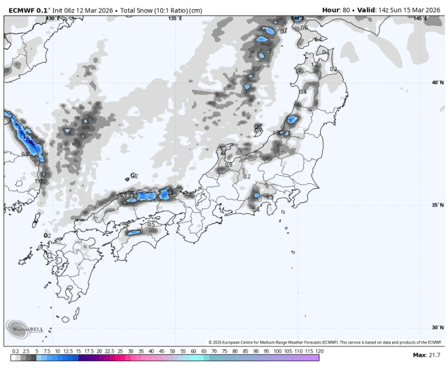
Snow develops Thursday night and Friday, then lingers in weaker waves into Sunday, with the most consistent support aimed at western Hokkaido. The individual models are converging fairly well on timing for this first push, and they are also in decent agreement on snow levels and generally manageable wind impacts, even though exact intensity still varies a bit. Kiroro is favored for around 20-30 cm through Sunday, while Niseko looks closer to 5-10 cm and most other Hokkaido areas closer to 2-8 cm. Honshu is lighter overall, generally 0-5 cm at most resorts, with Akakura the best chance to sneak toward 10 cm. Snow levels stay low enough for solid coverage, mostly below 300 meters in Hokkaido and around 300 to 700 meters in the Honshu snow, with occasional spikes near 1,000 meters on the southern fringe. Snow quality looks mostly moderate to fairly light with SLRs near 10-14 in Hokkaido, while lower Honshu bases lean denser at roughly 7-10 and higher terrain trends closer to 10-14. Exposed Hokkaido ridges can still see gusts in the 40 to 70 km/h range at times.
Monday through Wednesday trend much quieter, then late next week into next weekend carries much lower confidence. The individual models converge on a relatively dry stretch early next week, with only spotty light snow and no meaningful regional totals signal, while winds ease and mountain temperatures stay seasonably cool. From Thursday, March 19 onward, the individual models diverge sharply on timing, intensity, snow levels, and wind impacts. One camp keeps the more meaningful snow in Hokkaido with a modest 10-30 cm refresh, while another tries to build a much stronger Honshu event next weekend that could produce roughly 20-50 cm on favored central resorts if it verifies. The lower end is the safer call for now because a lot of guidance remains far weaker, and any stronger late-period solution would also bring more upper-mountain wind, with gusts potentially rising into the 60 to 100 km/h range on exposed terrain.
Resort Forecast Totals (Thu Mar 12 – Sun Mar 15)
Kiroro – 22-29 cm
Akakura Onsen – 9-11 cm
Niseko Grand Hirafu – 6-8 cm
Furano – 4-5 cm
Madarao Kogen – 4-5 cm
Naeba – 3-4 cm
Sapporo Teine – 3-4 cm
Gala Yuzawa – 2-3 cm
Nozawa Onsen – 2-3 cm
Hoshino Resort Tomamu – 2 cm
Rusutsu – 1-2 cm
Shiga Kogen Okushiga Kogen – 1-2 cm
Zao Onsen – 1-2 cm
Appi Kogen – 1 cm
Hakuba Happo-one – 0-1 cm
AloJapan.com