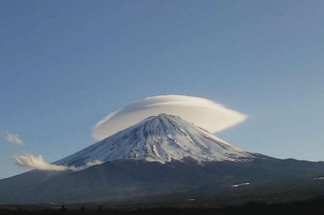
While marveling at views of iconic Mount Fuji, Hiroyuki Kusaka became intrigued when seeing the changing cloud patterns over the summit.
When the mountain’s cone-shaped peak is capped with a cloud, it sometimes looks as if it is wearing a straw hat, while a “tsurushi” cloud appears as if hanging from the sky.
“These clouds are incredibly beautiful and mysterious at the same time,” said Kusaka, a professor of urban and mountain meteorology at the University of Tsukuba. “I had always been curious about them and thought of it as particularly intriguing to look into them.”
Driven by curiosity, Kusaka embarked on a survey along with a team of scientists into the cloud patterns.
The team ascertained the weather conditions that produce the distinctive shapes of clouds over Mount Fuji, Japan’s tallest peak at 3,776 meters high.
The results came as the season was arriving in which the iconic summit can be seen clearly from afar, thanks to the crisp winter air.
As clouds with unique shapes add to the elegance of the sacred mountain, the researchers from the University of Tsukuba and the National Institute of Information and Communications Technology (NICT) joined forces in the latest study.
The team’s aim was to figure out the types of clouds most likely to form under certain conditions and the circumstances where specific shapes of cumulus appear.
“Our scientific data showed that the knowledge of people in the past based on their personal experiences was quite accurate,” Kusaka said. “Some formerly unknown conditions were revealed at this time as well too.”
According to Kusaka, cap-like forms and tsurushi lenticular-shaped clouds were traditionally said to manifest more frequently on “windy, humid days.” These beliefs had not been previously proved on a scientific basis.
VIDEOS SCREENED ALONG WITH WEATHER DATA
Kusaka and his colleagues recorded the skies with live cameras installed at seven locations around Mount Fuji over the three-year period from January 2019 through December 2021.
The images were combined with weather data collected from the mountain’s surrounding area for analysis.
The results showed that the most frequently observed design was the cap form. Cap clouds, including those obscured in part by other vapor masses, were seen for a total of 1,185 hours.
Cap clouds are generally divided into the summit-covering type and the detached type. As many as 77 percent covered the summit of Fuji, while the remaining cap clouds stayed well above the mountain top.
Tsurushi clouds were filmed for 1,000 hours overall. They fall into two categories based on their contours in general: ellipse tsurushi clouds and wing-shaped ones.
Ellipse ones represented the dominant variety, although wing-shaped clouds were previously believed to emerge more frequently.
Banner clouds, shaped like flying colors, were spotted in the recorded footage totaling 323 hours, the shortest among all forms.
Nearly 80 percent of banner clouds ran along the mountain ridge, resembling a horse’s mane in appearance. About 20 percent were considered the cumulus line type reminiscent of a fluttering streamer.
WINDS, MOISTURE, ATMOSPHERIC VIBRATIONS
Examining what conditions produce the various types of clouds, the researchers discovered that the key factors in particular lie in the wind direction, differing wind speeds at different altitudes, and the location of the moist air layer.
The upper part of Mount Fuji, around 3 kilometers above sea level, is normally subject to strong westward breezes due partially to the effects of prevailing westerly winds.
Both cap and tsurushi clouds, for example, form more easily on summer mornings characterized by relatively strong west-southwesterly winds.
It seems that summit-covering cap clouds often appear when the moist air layer sits near the peak, while the layer’s existing at a much higher altitude likely leads to the generation of the detached cap.
Tsurushi clouds readily emerge when the moist air layer is at a slightly higher altitude.
On the other hand, banner clouds are apt to form under the dry winter daytime conditions, as long as the wind is blowing from the west-northwest slightly to the north. The layer of moist air for banner clouds was found to be lower in altitude than the mountain peak.
The researchers similarly became aware that the mountain wave phenomenon, in which the atmosphere typically vibrates up and down when winds flow over Mount Fuji, plays a significant role as well.
Banner flags reportedly appear in most cases after winds bypass Fuji, gather on its leeward side and then create an updraft.
Kusaka expressed his high expectations for their findings, saying, “Exploring information on these elements effectively may someday allow us to encounter the type of cloud we are looking for with an increased probability.”
The research team’s outcome has been published in the specialized meteorological journal Weather at (https://rmets.onlinelibrary.wiley.com/doi/10.1002/wea.7774).
To further study the recently identified meteorological conditions for cloud formation, the team is currently proceeding with its numerical simulation. The simulation results will be reportedly closely examined.


AloJapan.com