

 Credit: WeatherBell
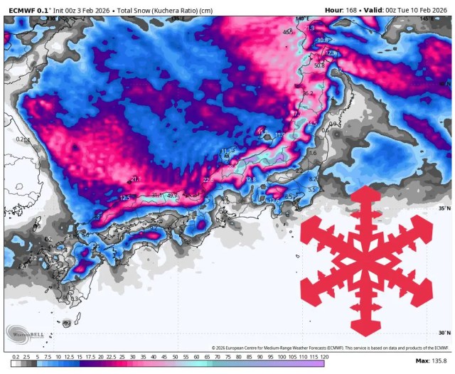
Japan stays in a very active winter pattern through early next week, with the most reliable snow from Thu night (02/05) through Mon (02/09) and frequent refreshes in Hokkaido. Snow levels sit at or near sea level for much of the period in Hokkaido, and that keeps precipitation as snow even down low while temperatures hold well below freezing. Snow quality should improve as colder air settles in, with SLRs often rising into the 16–19:1 range later in the weekend. On Honshu, the Sea of Japan side sees a stronger storm Fri (02/06)–Mon (02/09) with the heaviest push Sunday night, and most locations stay cold enough for solid powder once the main cold air arrives. Late next week (02/11–02/13) still carries storm potential, yet timing, snow levels, and totals remain less certain, and winds look like a bigger factor.
A small opener Tue night (02/03)–Wed (02/04) kicks things off in western Hokkaido, then a broader push arrives Thu night (02/05)–Sat (02/07) with colder air and stronger winds. Snow levels generally hover around 0 to 100 meters in Hokkaido during this stretch, so precipitation stays all snow, and temperatures run cold enough for consistent preservation. SLRs start in the low teens during the first part of the Hokkaido storm, then trend higher into the mid to upper teens, which points to improving snow quality from moderate to light and fluffy. Winds look most disruptive Thu night through Fri night on exposed terrain, with sustained 40–55 km/h flow and peak gusts pushing into the 90–110 km/h range at a few mountains. The GFS tends to emphasize the stronger pulses early, the ECMWF looks steadier, and the ICON often runs lighter, which keeps the exact storm peaks a bit uncertain even though the snowy pattern looks solid.
The Fri (02/06)–Mon (02/09) storm on Honshu is the main headline, with the strongest snowfall rates most likely Sunday night (02/08) and into Monday as northwest flow strengthens. Snow levels drop quickly toward 0 meters at many locations once the storm gets established, and overnight temperatures settle into a consistently cold range that supports good snow quality. SLRs on the Sea of Japan side mostly sit in the 13–18:1 zone for good powder, while some lower and mid-mountain periods run closer to 10–13:1 and can ski a bit denser. Winds also ramp up on ridges late Sunday into Monday, with several areas showing 70–100 km/h gust potential that can impact upper-mountain lift operations. The ECMWF remains notably lower than the GFS in parts of central Honshu, while the GDPS sometimes pushes higher totals, which supports strong confidence in widespread new snow and moderate confidence on who lands the biggest local bullseyes. For open Hokkaido resorts like Kiroro, Niseko Grand Hirafu, Rusutsu, and Furano, the best turns should line up Saturday night through Monday when SLRs climb into the 16–19:1 range and winds relax a bit between pulses.
Resort Forecast Totals (02/03–02/10)
Akakura Onsen – 58 cm–101 cm Fri (02/06) – Mon (02/09)
Kiroro – 49 cm–82 cm total (3 cm–4 cm Tue night (02/03) – Wed (02/04) + 20 cm–31 cm Thu night (02/05) – Sat (02/07) + 26 cm–48 cm Sat night (02/07) – Tue (02/10))
Gala Yuzawa – 47 cm–82 cm Fri (02/06) – Mon (02/09)
Niseko Grand Hirafu – 47 cm–77 cm total (6 cm–7 cm Tue night (02/03) – Wed (02/04) + 41 cm–70 cm Thu night (02/05) – Mon night (02/09))
Nozawa Onsen – 42 cm–73 cm Fri (02/06) – Mon (02/09)
Madarao Kogen – 42 cm–72 cm Fri (02/06) – Mon (02/09)
Naeba – 35 cm–61 cm Fri (02/06) – Mon (02/09)
Sapporo Teine – 30 cm–51 cm total (10 cm–14 cm Thu night (02/05) – Sat (02/07) + 20 cm–36 cm Sat night (02/07) – Mon (02/09))
Shiga Kogen Okushiga Kogen – 25 cm–45 cm Fri night (02/06) – Mon (02/09)
Furano – 25 cm–44 cm total (12 cm–19 cm Thu night (02/05) – Sat night (02/07) + 13 cm–25 cm Sun night (02/08) – Tue (02/10))
Rusutsu – 26 cm–43 cm total (15 cm–22 cm Thu night (02/05) – Sat (02/07) + 11 cm–21 cm Sun (02/08) – Mon night (02/09))
Appi Kogen – 25 cm–40 cm Wed (02/04) – Mon night (02/09)
Hoshino Resort Tomamu – 21 cm–34 cm total (15 cm–23 cm Thu night (02/05) – Sat (02/07) + 6 cm–11 cm Sun night (02/08) – Mon night (02/09))
Hakuba Happo-one – 18 cm–32 cm Sat (02/07) – Mon (02/09)
Zao Onsen – 10 cm–16 cm total (4 cm–6 cm Wed night (02/04) – Fri (02/06) + 5 cm–10 cm Sat night (02/07) – Mon (02/09))
AloJapan.com