
 Credit: WeatherBell
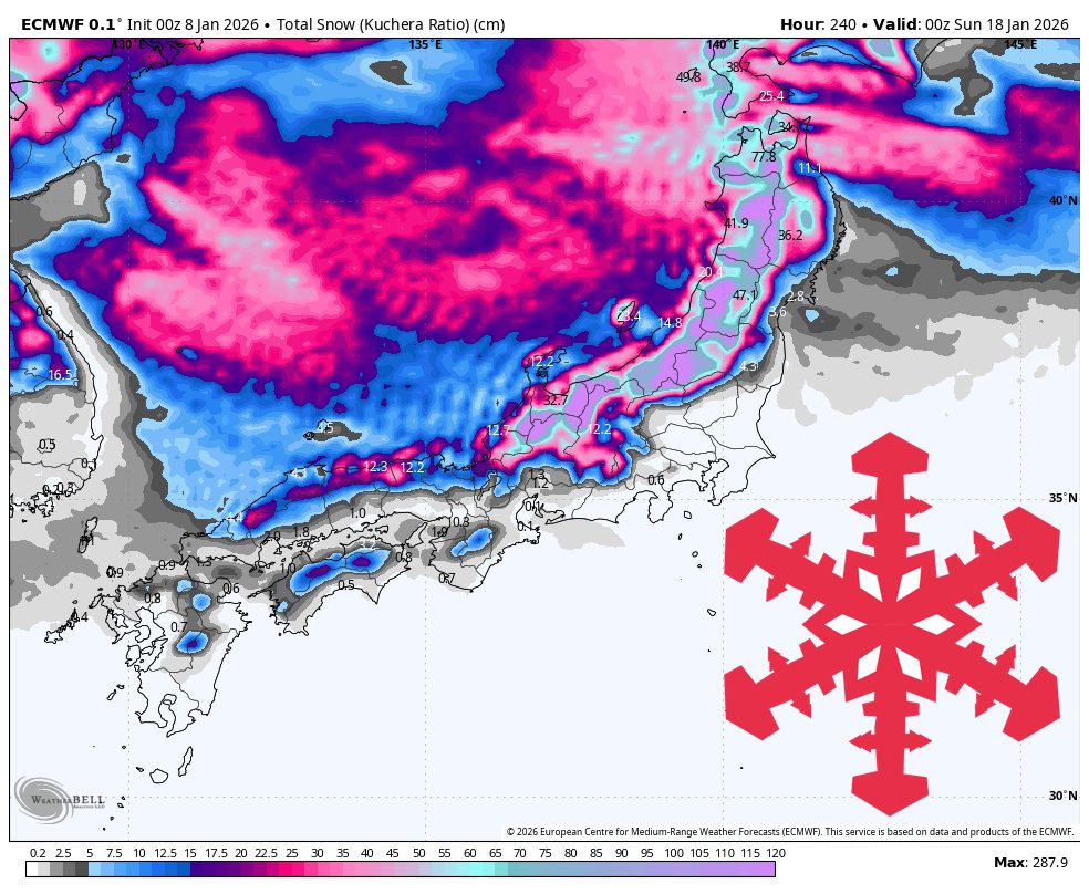
Japan is lined up for a busy January 8–18 stretch with multiple snow-producing waves, highlighted by a major weekend dump and several follow-up refreshers before a warmer, windier finish late week. Central Honshu is the headline with multi-storm totals reaching 50″–80″, while Hokkaido’s open resorts keep stacking frequent, generally higher-quality snow that adds up to 20″–65″, with periodic wind impacts on the most exposed terrain.
The opening salvo Thursday night (01/08)–Friday (01/09) is a quick, lighter hit, then the main event ramps up Saturday night (01/10)–Monday night (01/12). That weekend storm is the real base-builder for Central Honshu, with snow levels largely staying low enough to keep skiing conditions wintry, and temperatures trending coldest overnight as the best accumulations roll through. Snow quality during the heart of the weekend system is mostly in the 10–16:1 SLR range, so expect a mix of moderately fluffy turns where it stays colder and slightly denser snow during the warmer periods. Totals from this phase alone push into the 15″–45″ range in the Japanese Alps core, led by the Hakuba zone and nearby mountains.
A secondary reload follows Tuesday (01/13)–Thursday (01/15), then a broader late-week push arrives Thursday night (01/15)–Sunday night (01/18) with noticeably higher snow levels at times. The midweek wave stays productive and often improves snow quality with SLRs frequently in the 13–17:1 range as colder air reasserts itself overnight, adding meaningful new coverage on top of the weekend base. Late week, snow levels spike periodically into the 2,000–3,200 feet range in parts of Central Honshu, and SLRs trend lower in several areas (often 6–12:1), so expect denser snow and more variable quality at lower elevations even while upper terrain continues to cash in. Winds also become a bigger factor late week, especially in more exposed zones where gusts can interfere with the on-mountain experience.
Hokkaido keeps the most consistent drumbeat of snowfall through the whole window, with snow levels near sea level and temperatures commonly in the teens to low 20s supporting frequent refreshes. Open resorts like Niseko Grand Hirafu, Kiroro, Rusutsu, and Furano stay in the sweet spot for steady accumulation, and SLRs generally run in the 12–18:1 range, so the snow trends fairly good to outright fluffy outside of a few denser windows. The main watch item is wind, with several periods featuring strong ridge-top speeds and gusts that can reach into the 60–80 mph range at times, so the most exposed lifts and upper terrain may not always ski as friendly even as snow continues to add up. Farther north and east, wind is an even bigger storyline at times (including very strong gusts in the Tohoku zone), which can limit how “skiable” the fresh feels despite additional snowfall.
Resort Forecast Totals
Hakuba Happo-one – 47″–81″ total (29″–45″ Sat night (01/10) – Mon (01/12) + 11″–21″ Tue (01/13) – Wed night (01/14) + 7″–16″ Thu night (01/15) – Sun night (01/18))
Nozawa Onsen – 37″–70″ total (1″–2″ Thu night (01/08) – Fri (01/09) + 16″–25″ Sat night (01/10) – Mon night (01/12) + 9″–17″ Tue night (01/13) – Thu (01/15) + 11″–27″ Thu night (01/15) – Sun night (01/18))
Kiroro – 34″–66″ total (25″–42″ Thu night (01/08) – Fri (01/16) + 9″–24″ Fri night (01/16) – Sun night (01/18))
Akakura Onsen – 36″–66″ total (19″–29″ Sat night (01/10) – Mon night (01/12) + 9″–17″ Tue night (01/13) – Wed night (01/14) + 8″–20″ Thu night (01/15) – Sun night (01/18))
Gala Yuzawa – 33″–62″ total (2″–3″ Thu night (01/08) – Fri (01/09) + 13″–20″ Sun (01/11) – Mon night (01/12) + 9″–18″ Tue night (01/13) – Thu (01/15) + 9″–22″ Fri (01/16) – Sun night (01/18))
Madarao Kogen – 31″–59″ total (16″–25″ Sat night (01/10) – Mon night (01/12) + 6″–12″ Tue night (01/13) – Thu (01/15) + 9″–22″ Thu night (01/15) – Sun night (01/18))
Appi Kogen – 33″–57″ total (31″–51″ Thu night (01/08) – Fri (01/16) + 2″–5″ Fri night (01/16) – Sun night (01/18))
Naeba – 29″–56″ total (1″–2″ Thu night (01/08) – Fri (01/09) + 14″–21″ Sat night (01/10) – Mon night (01/12) + 5″–10″ Tue night (01/13) – Thu (01/15) + 9″–24″ Thu night (01/15) – Sun night (01/18))
Niseko Grand Hirafu – 31″–55″ total (28″–45″ Thu night (01/08) – Fri (01/16) + 3″–9″ Fri night (01/16) – Sun night (01/18))
Shiga Kogen Okushiga Kogen – 26″–50″ total (1″ Thu night (01/08) – Fri (01/09) + 12″–18″ Sun (01/11) – Mon night (01/12) + 5″–10″ Tue night (01/13) – Wed night (01/14) + 8″–21″ Thu night (01/15) – Sun night (01/18))
Furano – 24″–43″ total (3″–4″ Thu night (01/08) – Sat (01/10) + 21″–39″ Sat (01/10) – Sun night (01/18))
Zao Onsen – 22″–40″ total (12″–19″ Sat night (01/10) – Mon night (01/12) + 10″–21″ Tue (01/13) – Sun night (01/18))
Rusutsu – 22″–38″ total (3″–4″ Thu night (01/08) – Sat (01/10) + 17″–29″ Sat (01/10) – Fri (01/16) + 2″–5″ Fri night (01/16) – Sun night (01/18))
Hoshino Resort Tomamu – 16″–26″ total (14″–23″ Sat (01/10) – Thu night (01/15) + 1″–3″ Sat (01/17) – Sun night (01/18))
Sapporo Teine – 10″–21″ total (2″ Sat night (01/10) – Sun (01/11) + 1″–2″ Sun night (01/11) – Mon night (01/12) + 4″–8″ Tue (01/13) – Wed night (01/14) + 3″–9″ Fri night (01/16) – Sun night (01/18))
AloJapan.com