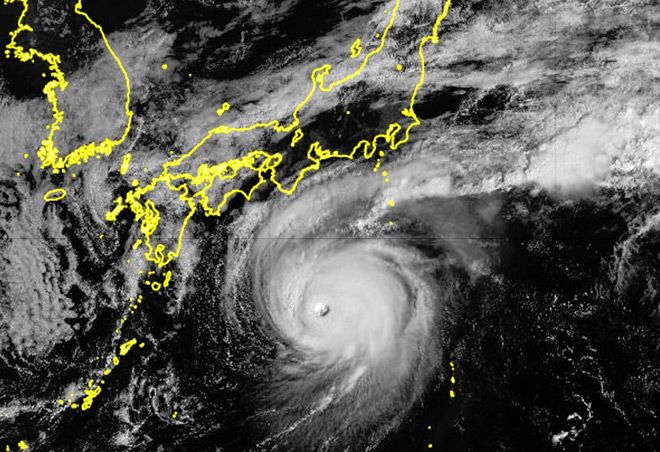
The ferocity of Typhoon No. 22 as it approaches the Izu islands on Oct. 8 prompted the Japan Meteorological Agency to issue a rare special emergency warning for violent winds and high waves.
The special warning, the first ever for the Izu island chain south of Tokyo, was issued for Hachijo town and Aogashima village.
Depending on the future path of the typhoon, the warning area could expand to include other municipalities on the islands, the JMA said.
“There will be violent winds of a kind never experienced before that are strong enough to destroy some homes,” the agency said. “Maximum caution is required, with personal safety as the top priority.”
The agency has urged residents on the islands to evacuate to shelters before the rain and winds further intensify.
The JMA also warned that linear rainbands may form between the early hours and late morning on Oct. 9, raising the risk of torrential rain.
As of 3 p.m. on Oct. 8, Typhoon No. 22 was located about 300 kilometers southwest of Aogashima island and moving north-northeast at about 20 kph. Its central pressure was 935 hectopascals, with maximum sustained winds of 180 kph near the center and maximum instantaneous wind gusts of 252 kph.
The typhoon rapidly intensified due to high sea surface temperatures along its path. It is expected to maintain its strength as it nears the Izu island chain through Oct. 9.
Special emergency warnings for typhoons are issued when conditions are comparable to the 1959 Ise Bay Typhoon, which killed or left missing more than 5,000 people nationwide. Such strong storms are considered once-in-several-decades events.
These typhoons have a central pressure below 930 hectopascals or maximum wind speeds of 180 kph or more.
The special warning issued for Typhoon No. 22 is the first since Typhoon No. 10 struck southern Kyushu in August 2024, and the fifth since the emergency warning system was introduced in 2013.
The agency also reported that Typhoon No. 23 had formed east of the Philippines on the afternoon of Oct. 8.
It was moving north-northwest at about 30 kph with a central pressure of 1,002 hectopascals, maximum sustained winds near the center of nearly 65 kph, and maximum instantaneous wind gusts of 90 kph.
It may approach the area near Okinawa Prefecture around Oct. 11 and move along the southern Pacific coast of Japan through Oct. 13.
The agency is urging the public to stay alert for updated weather conditions.


AloJapan.com