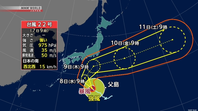
Typhoon Halong is now moving west over waters south of Japan. Japanese weather officials say the storm may become very strong and approach Japan’s Izu Islands on Thursday.
The Meteorological Agency says as of 12 p.m. on Tuesday, the typhoon was located over the Pacific south of Japan and moving west-northwest at a speed of 15 kilometers per hour. It had a central atmospheric pressure of 970 hectopascals and was packing winds up to 144 kilometers per hour near its center.
Peak gusts were estimated at 198 kilometers per hour and winds were blowing at a speed of 90 kilometers per hour or faster within a 55 kilometer-radius of the storm center.
The officials are warning people on the Ogasawara Islands to be on alert for strong winds and high waves.
The typhoon is expected to develop and gradually change its course toward the northeast. It may approach the Izu Islands on Thursday as a very strong typhoon.
Strong winds and rough seas are expected on and near the islands on Wednesday and the condition could further intensify on Thursday.


AloJapan.com