

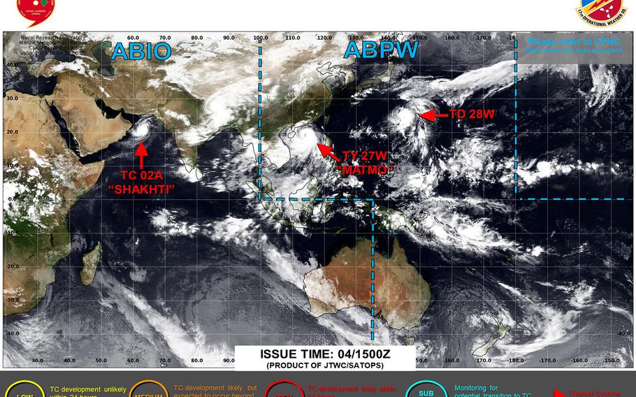
Tropical Depression 28W forms east of Iwo Jima, forecast to venture close to Okinawa by mid-week next. (Joint Typhoon Warning Center)
Midnight Saturday, Oct. 4, Japan time: Say hello to Tropical Depression 28W.
The new system spawned Saturday and according to the initial Joint Typhoon Warning Center forecast track, 28W is projected to head west in Okinawa’s general direction, peak as a Category 3-equivalent typhoon, but curve northeast away from the island before reaching us.
At 9 p.m., 28W was about 125 miles east of Iwo Jima and some 970 miles east of Kadena Air Base, tracking north at 9 mph with 35-mph sustained winds and 45-mph gusts. U.S. bases on Okinawa remain in seasonal Tropical Cyclone Condition of Readiness 4.
JTWC’s initial forecast track takes 28W about 150 miles east-northeast of Kadena just past midnight Wednesday, packing 120-mph sustained winds and 150-mph gusts at center, Category 3-equivalent intensity. Current projection shows Okinawa just outside of 28W’s destructive wind bands.
Bear in mind, 28W is a very young system. Much could change regarding forecast track. Model track guidance is wide and varied, as are the GFS and Euro forecast ensembles. Some solutions show a straight run to Taiwan; others curving northeast toward Japan. Whichever app you use, don’t take what you currently see as the final answer.
Still, it is mighty prudent to prepare. Okinawa bases remain in seasonal TCCOR 4 because the island rests close to the area where tropical cyclones are apt to form and become strong. That doesn’t mean this one will or won’t. Could or might always applies to tropical cyclones.
We haven’t dealt with anything significant thus far this season. So, take a look around house and apartment. Do a general cleanup. Take a peek at what’s in your closets. Make a list of what you need to ride things out. Just in case. It never hurts. Prepare. Don’t panic.
AloJapan.com