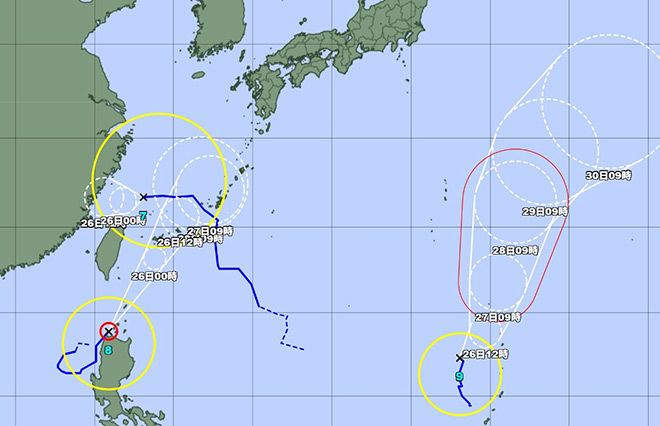
Japan is currently facing a rare triple typhoon formation in waters south of the archipelago, with Typhoons No. 7, 8 and 9 simultaneously active.
Of these, the season’s eighth typhoon is expected to approach Okinawa Prefecture on the evening of July 25.
Due to the humid air surrounding the typhoon, there is a risk of linear rainbands forming over Kagoshima Prefecture, excluding the Amami islands, from late July 25 through late July 26, heightening the risk of severe rain-related disasters.
As of noon on July 25, Typhoon No. 8 was traveling north-northeast over the sea south of Japan at a speed of 20 kph.
The typhoon had a central atmospheric pressure of 985 hectopascals, with maximum instataneous wind speeds near the center reaching 108 kph.
On July 26, Okinawa’s main island is expected to experience heavy rain, with authorities urging residents to be on high alert for landslides and flooding in low-lying areas.
The southern part of the Kyushu main island and the Amami region may also experience extremely heavy rain and thunderstorms through late on July 26.
Meanwhile, Typhoon No. 7, which is moving northwest over the East China Sea, is expected to weaken into a tropical depression later on July 25.
Typhoon No. 9 continues to barrel north near the Mariana islands, but it is not expected to have a major impact on Japan’s main islands.


AloJapan.com