
, # 6; Tropical Storm 11W, # 3; 98W Invest")
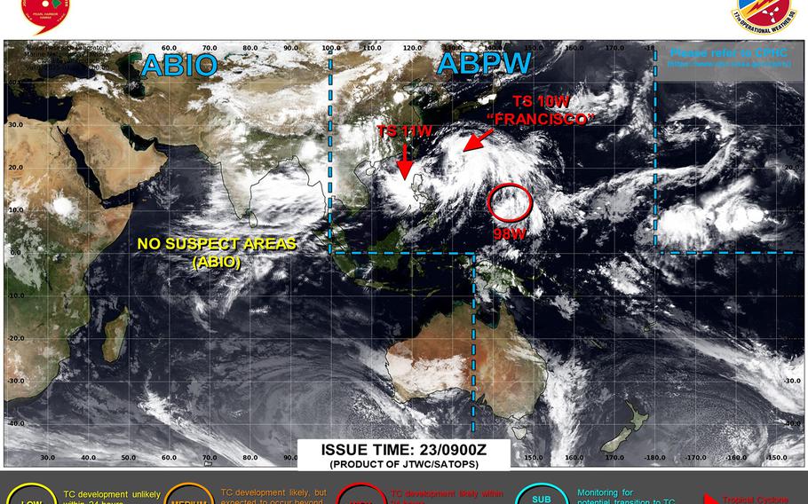
Francisco and 11W continue gradually strengthening, lurking west of Luzon; Francisco continues moving north, forecast to pass 70 miles southwest of Okinawa Thursday evening; 98W keeps lurking near Guam. (Joint Typhoon Warning Center)
11:10 p.m. Wednesday, July 23, Japan time: Traffic continues to get heavier along Typhoon Turnpike. Tropical Storm Francisco and Tropical Storm 11W are getting gradually stronger, 98W Invest is gaining ground near Guam and Okinawa is already feeling the effects of Francisco as it approaches from the southeast.
Already, flights in to and out of Okinawa’s Naha International Airport on Thursday are either being canceled or delayed, in some cases significantly. Check flight status for All-Nippon Airways and Japan Air Lines here.
At 9 p.m., Francisco was about 325 miles south-southeast of Kadena Air Base, wobbling west-northwest at 7 mph, and holding steady at 46-mph sustained winds and 58-mph gusts at center.
U.S. bases on Okinawa remained in seasonal Tropical Cyclone Condition of Readiness 4 through Wednesday evening. Still not expecting accelerated TCCORs, but of course that can always change depending on proximity to Okinawa and strength.
Joint Typhoon Warning Center continues to project Francisco peaking at 52-mph sustained winds and 63-mph gusts at mid-morning Thursday, with closest point of approach to Kadena forecast for about 90 miles southwest at 6 p.m. Thursday.
Kadena’s extended forecast continues to call for gusts up to 40 mph, with scattered showers, some heavy at times, and isolated thunderstorms. Looking at between 5 to 7 inches of rain associated with Francisco.
As for 11W, at 8 p.m. Philippines time, it was 270 miles north-northwest of Metro Manila and 815 miles southwest of Kadena, moving west at 9 mph with 46-mph sustained winds and 58-mph gusts at center.
JTWC projects 11W to peak at 70-mph sustained winds and 86-mph gusts at center just before making landfall in northwest Luzon around mid-evening Thursday, exiting Luzon’s north coast several hours later, then diminishing as it heads northeast over open water.
Then, there’s 98W Invest, which at 4 p.m. Guam time was about 40 miles south-southeast of Andersen Air Force Base. JTWC has issued a tropical cyclone formation alert on the system.
Expect gusty winds and showers, heavy at times, and isolated thunderstorms; National Weather Service forecasts between 6 to 12 inches of rain.
We continue to keep one eyeball down south on 90W Invest. More on that as it attempts to develop.
AloJapan.com