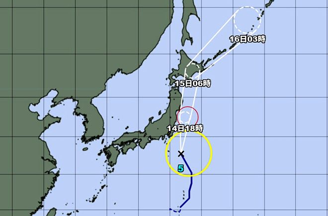
Typhoon No. 5 gained intensity as it approached eastern Japan on July 14, threatening to bring strong winds, high waves and heavy rain that could trigger landslides, the Japan Meteorological Agency said.
The typhoon is expected to pass east of the Kanto region and lash the Sanriku coast of the northeastern Tohoku region by the evening of July 14.
As of 9 a.m. on July 14, the typhoon was located about 210 kilometers south-southeast of Choshi, Chiba Prefecture, and traveling northward at 35 kph.
It had a central pressure of 985 hectopascals, a maximum wind speed of 90 kph near its eye, and a maximum instantaneous wind speed of 126 kph.
Eastern and northern Japan are expected to experience very strong winds and rough seas with large swells.
Up to 120 millimeters of rain is expected in the 24 hours through 6 a.m. on July 15 in parts of the northern and southern Kanto regions as well as parts of the Pacific coast of the Tohoku region.
Some areas of Hokkaido could also receive up to 100 mm of rain, the JMA said.
Typhoon No. 5 is expected to move toward Hokkaido on July 15 and will then likely be downgraded to an extratropical cyclone.
In western Japan, a tropical cyclone is causing heavy rainfall. The JMA warned that linear rainbands could form over the Tokai region from the night of July 14 through the morning of July 15.


AloJapan.com